News

Friday, 22 November 2013

The Great Wall of China

The Great Wall of China is a series of fortifications made of stone, brick, tamped earth, wood, and other materials, generally built along an east-to-west line across the historical northern borders of China in part to protect the Chinese Empire or its prototypical states against intrusions by various nomadic groups or military incursions by various warlike peoples or forces.


Several walls were being built as early as the 7th century BC; these, later joined together and made bigger and stronger, are now collectively referred to as the Great Wall. Especially famous is the wall built between 220–206 BC by the first Emperor of China, Qin Shi Huang. Little of that wall remains. Since then, the Great Wall has on and off been rebuilt, maintained, and enhanced; the majority of the existing wall was reconstructed during the Ming Dynasty.


Other purposes of the Great Wall have included border controls, allowing the imposition of duties on goods transported along the Silk Road, regulation or encouragement of trade and the control of immigration and emigration. Furthermore, the defensive characteristics of the Great Wall were enhanced by the construction of watch towers, troop barracks, garrison stations, signaling capabilities through the means of smoke or fire, and the fact that the path of the Great Wall also served as a transportation corridor.


The Great Wall stretches from Shanhaiguan in the east, to Lop Lake in the west, along an arc that roughly delineates the southern edge of Inner Mongolia. A comprehensive archaeological survey, using advanced technologies, has concluded that the Ming walls measure 8,850 km (5,500 mi). This is made up of 6,259 km (3,889 mi) sections of actual wall, 359 km (223 mi) of trenches and 2,232 km (1,387 mi) of natural defensive barriers such as hills and rivers. Another archaeological survey found that the entire wall with all of its branches measure out to be 21,196 km (13,171 mi).


A more controversial question is whether the Wall is visible from low Earth orbit (an altitude of as little as 100 miles (160 km)). NASA claims that it is barely visible, and only under nearly perfect conditions; it is no more conspicuous than many other man-made objects. Other authors have argued that due to limitations of the optics of the eye and the spacing of photoreceptors on the retina, it is impossible to see the wall with the naked eye, even from low orbit, and would require visual acuity of 20/3 (7.7 times better than normal).
Read more ...

Tuesday, 12 November 2013

Bali Island Indonesia

Bali is an island and a province of Indonesia, the nation's smallest province. The province covers a few smaller neighbouring islands, notably Nusa Penida, as well as the island of Bali itself. It is located at the westernmost end of the Lesser Sunda Islands, between Java to the west and Lombok to the east. One of the country's 34 provinces, Bali has its capital at Denpasar towards the south of the island.


With a population recorded as 3,890,757 in the 2010 census, and currently 4.22 million, the island is home to most of Indonesia's Hindu minority. According to the 2010 Census, 84.5% of Bali's population adhered to Balinese Hinduism while most of the remainder followed Islam. Bali is also the largest tourist destination in the country and is renowned for its highly developed arts, including traditional and modern dance, sculpture, painting, leather, metalworking, and music.


A tourist haven for decades, the province has seen a further surge in tourist numbers in recent years. Bali was inhabited by around 2000 BC by Austronesian people who migrated originally from Southeast Asia and Oceania through Maritime Southeast Asia. Culturally and linguistically, the Balinese are thus closely related to the people of the Indonesian archipelago, Malaysia, the Philippines, and Oceania.


The island of Bali lies 3.2 km (2 mi) east of Java, and is approximately 8 degrees south of the equator. Bali and Java are separated by the Bali Strait. East to west, the island is approximately 153 km (95 mi) wide and spans approximately 112 km (69 mi) north to south; administratively it covers 5,780 km2, or 5,577 km2 without Nusa Penida District, its population density is roughly 750 people/km2.


Some of the worst erosion has occurred in Lebih Beach, where up to 7 meters of land is lost every year. Decades ago, this beach was used for holy pilgrimages with more than 10,000 people, but they have now moved to Masceti Beach. From ranked third in previous review, in 2010 Bali got score 99.65 of Indonesia's environmental quality index and the highest of all the 33 provinces.

Read more ...

Alaska State of USA

Alaska is a U.S. state situated in the northwest extremity of the North American continent. Bordering the state is Canada to the east, the Arctic Ocean to the north, and the Pacific Ocean to the west and south, with Russia (specifically, Siberia) further west across the Bering Strait. Alaska is the largest state in the United States by area, the 4th least populous and the least densely populated of the 50 United States.


Approximately half of Alaska's 731,449 residents live within the Anchorage metropolitan area. Alaska's economy is dominated by the oil, natural gas, and fishing industries, resources which it has in abundance. Tourism is also a significant part of the economy. Although it had been occupied for thousands of years by indigenous peoples, from the 18th century onward, European powers considered the territory of Alaska ripe for exploitation.


The United States purchased Alaska from Russia on March 30, 1867, for $7.2 million ($120 million adjusted for inflation) at approximately two cents per acre ($4.74/km²). The area went through several administrative changes before becoming organized as a territory on May 11, 1912. It was admitted as the 49th state of the U.S. on January 3, 1959.

Photo Source: Link

The name "Alaska" (Аляска) had been introduced in the Russian colonial period, when it was used to refer to the peninsula. It is derived from the Aleut alaxsxaq, meaning "the mainland" or, more literally, "the object towards which the action of the sea is directed". It is also known as Alyeska, the "great land", an Aleut word derived from the same root.


With its myriad islands, Alaska has nearly 34,000 miles (54,720 km) of tidal shoreline. The Aleutian Islands chain extends west from the southern tip of the Alaska Peninsula. Many active volcanoes are found in the Aleutians and in coastal regions. Unimak Island, for example, is home to Mount Shishaldin, which is an occasionally smoldering volcano that rises to 10,000 feet (3,048 m) above the North Pacific.

Read more ...

Monday, 11 November 2013

Koh Samui Island

Ko Samui or Koh Samui or often simply Samui as it is referred to by locals, is an island off the east coast of the Kra Isthmus in Thailand. It is located close to the mainland town of Surat Thani in Surat Thani Province. It is Thailand's second largest island after Phuket, with an area of 228.7 km2 and a population of over 63,000 attracting 1.5 million tourists per year.

 Koh Samui
 Koh Samui
 Koh Samui
 Koh Samui
 Koh Samui Island
Read more ...

Sunday, 10 November 2013

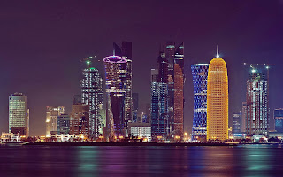
Doha Tower

Doha Tower also known as Burj Doha and previously named as Burj Qatar and Doha High Rise Office Building, is an iconic high rise tower located in West Bay (Doha), Doha, Qatar. On October 18, 2012, the building received the CTBUH Skyscraper Award for the Best Tall Building Worldwide from the CTBUH. Doha Tower was designed by renowned French architect Jean Nouvel.

 Doha Tower
 Doha Tower
 Doha Tower
 Doha Tower
 Doha Tower
Read more ...

Sunday, 3 November 2013

Paradise Island

Paradise Island is an island in the Bahamas formerly known as Hog Island. The island, with an area of 685 acres (277 ha) (1.1 sq mi/2.8 km2), is located just off the shore of the city of Nassau, which is itself located on the northern edge of the island of New Providence. It is best known for the sprawling resort Atlantis with its extensive water park rides, pools, beach, restaurants, walk-in aquarium and casinos.

 Paradise Island
 Paradise Island
 Paradise Island
 Paradise Island
 Paradise Island Bahamas
Read more ...

Saturday, 2 November 2013

Dead Sea

The Dead Sea also called the Salt Sea, is a salt lake bordering Jordan to the east and Israel and Palestine to the west. Its surface and shores are 423 metres (1,388 ft) below sea level, Earth's lowest elevation on land. The Dead Sea is 377 m (1,237 ft) deep, the deepest hypersaline lake in the world. With 33.7% salinity, it is also one of the world's saltiest bodies of water, though Lake Assal (Djibouti), Garabogazköl and some hypersaline lakes of the McMurdo Dry Valleys in Antarctica (such as Don Juan Pond) have reported higher salinities.

 Dead Sea
 Dead Sea
 Dead Sea
 Dead Sea
Salt Sea
Read more ...

Blog Archive

Contact us

Name

Email *

Message *